UK Traffic and Accident Analysis: Data-Driven Insights for Road Safety
- Mukesh Shirke

- May 25
- 3 min read
Updated: May 26
An R-powered exploratory analysis of UK road traffic and accident data was performed to identify trends in accident frequency, severity, and contributing factors. By integrating multi-year datasets and leveraging interactive visualizations, this project aims to support data-driven decision-making for policymakers and public safety stakeholders.
Link to UK Traffic and Accident Dashboard:
GitHub Repository:
Snapshot:


Project Background and Overview
The project leverages recent UK road accident data to uncover actionable insights into accident frequency, severity, and contributing factors. The analysis is aimed at supporting stakeholders—such as policymakers, road safety authorities, and the public—in understanding key patterns and developing targeted interventions to improve road safety.
Data Structure Overview
Data Source
UK Department for Transport open datasets (latest available, up to 2024)
Data covers accident records with attributes including date, time, location, severity, weather, road surface, and vehicle type.
Files Used:
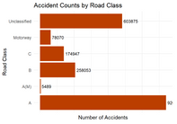
Accident_Information.csv file – accident_index, road_class, road_number, date, time, junction_detail, light_detail, road_surface_conditions, weather_conditions
Data Preparation
Removed duplicates and handled missing values
Standardized column names, date/time formats, and categorical variables
Merged datasets for multi-year, multi-factor analysis
Data Limitations
Underreporting of minor accidents possible
Some environmental factors (e.g., lighting, signage) may be inconsistently recorded
No direct behavioral data (e.g., driver distraction, intoxication)
Analysis Summary
This analysis highlights critical trends and risk factors in UK road accidents. While the total number of accidents has shown a gradual decline, the proportion of serious and fatal incidents remains a concern. Key findings reveal strong links between accident severity and factors such as weather, road surface, and time of day. The dashboard enables users to filter and explore data by year, region, severity, and contributing factors.
Snapshot of Findings:
Declining trend in total accidents, but serious/fatal cases remain steady
Wet or icy road surfaces and poor weather conditions significantly increase accident severity
Peak accident times align with rush hours and poor visibility periods
Motorcycles and young drivers are overrepresented in severe accidents
Insights Deep Dive
1. Accident Severity by Weather and Road Surface Wet/icy surfaces and adverse weather conditions see a 40% higher rate of serious/fatal accidents compared to dry/clear conditions
Business Metric: Accident severity index
Story: Targeted road maintenance and weather-responsive alerts can mitigate risk
2. Temporal Patterns Accidents peak during weekday rush hours (8–10 AM, 4–7 PM)
Nighttime accidents, though less frequent, are more likely to be severe
Business Metric: Accidents per hour, severity by time of day
Story: Enhanced enforcement and public awareness during high-risk periods
3. Vehicle and Demographic Analysis Motorcycles and young male drivers have higher involvement in severe accidents
Business Metric: Severity rate by vehicle type and driver age
Story: Focused education and enforcement for high-risk groups
4. Regional Hotspots Urban centers report more accidents, but rural roads have higher fatality rates
Business Metric: Accidents and fatalities per 100,000 population by region
Story: Infrastructure improvements and tailored interventions needed in rural areas
Recommendations
Dynamic Road Safety Campaigns: Launch targeted awareness and enforcement during high-risk times and adverse weather conditions.
Infrastructure Upgrades: Prioritize improvements on rural and high-severity corridors (e.g., better lighting, signage, surface treatments).
Data-Driven Policy: Use dashboard insights to inform local and national road safety strategies.
Further Data Collection: Integrate behavioral and vehicle telematics data for deeper analysis.
How to Use
1. Explore the Dashboard:
Filter by year, severity, region, weather, and road type
Visualize trends, hotspots, and key risk factors
2. Reproduce the Analysis:
Download the data and code from this repository
Follow the documented RMarkdown/HTML workflow for data cleaning, analysis, and visualization
Author
Mukesh Shirke
Explore the RMarkdown file for detailed code, data cleaning steps, visualizations, and the full analysis process. This project demonstrates my expertise in data analysis, R programming, and the application of data-driven insights to real-world challenges in urban analytics.


Comments